
#WalangPasok: Updated List of Work and Class cancellations for August 30, 2023 (Wednesday)
Manila, Philippines – Several Local Government Units and Schools in the Philippines suspended classes and government work on Wed, August 30, 2023, due to Typhoon Goring (Saola) and the enhanced southwest monsoon.

Walang Pasok Updates: August 30, 2023, Miyerkules
(As of 4:18pm, August 29, 2023) Here’s an updated list of towns, cities, and schools that canceled classes/work on Wednesday:
Cagayan Valley
-
- Cagayan Province – all levels (public and private) (source)
Ilocos Region
- Dagupan City – all levels (public and private) (source)
- Ilocos Sur
- Magsingal – all levels (public and private) (source)
Western Visayas
- Guimaras Province – Preschool to elementary (public and private) (source)
- Iloilo province
- Dumangas – all levels (public and private) (source)
- Iloilo City – preschool to senior high school (public and private)
- Negros Occidental
- Bacolod City – all levels (public and private) (source)
Forecast Weather Conditions Issued at 4:00 PM, 29 August 2023
SYNOPSIS: At 3:00 PM today, the center of the eye of Typhoon “GORING” {SAOLA} was estimated based on all available data at 165 km East Southeast of Calayan, Cagayan (18.9°N, 123.0°E) with maximum sustained winds of 165 km/h near the center and gustiness of up to 205 km/h. It is moving West Northwestward at 10 km/h. Southwest Monsoon affecting Central and Southern Luzon, Visayas, and Mindanao.
| Place | Weather Condition | Caused By | Impacts |
|---|---|---|---|
| Batanes and Northeastern Cagayan including Babuyan Islands | Stormy | TY Goring | Possible flooding or landslides due to moderate to heavy rains. Minor to moderate threat to lives and properties due to strong winds. |
| Ilocos Norte, Apayao, rest of mainland Cagayan, and Isabela | Rains with gusty winds | TY Goring | Possible flooding or landslides due to moderate to heavy rains. Minimal to minor threat to lives and properties due to strong winds. |
| Zambales, Bataan, Occidental Mindoro, and northern portion of Palawan | Monsoon Rains | Southwest Monsoon | Possible flooding or landslides due to scattered to widespread rains |
| Western Visayas, the rest of Central Luzon, the rest of MIMAROPA, Cavite, and Batangas | Occasional Rains | Southwest Monsoon | Possible flooding or landslides due to moderate to heavy rains |
| Metro Manila, Zamboanga Peninsula, the rest of Luzon, and the rest of Visayas | Cloudy skies with scattered rainshowers and thunderstorms | Southwest Monsoon | Possible flooding or landslides due to moderate with at times heavy rains |
| The rest of Mindanao | Partly cloudy to cloudy skies with isolated rainshowers or thunderstorms | Southwest Monsoon / Localized Thunderstorms | Possible flash floods or landslides during severe thunderstorms |
Super Typhoon Goring
Issued at 11:00 pm, 29 August 2023 (Valid for broadcast until the next advisory to be issued at 2:00 AM tomorrow)
VIOLENT, LIFE-THREATENING CONDITIONS NOW PREVAIL OVER PORTIONS OF BABUYAN ISLANDS AS GORING INTENSIFIES INTO A SUPER TYPHOON
HAZARDS AFFECTING LAND AREAS
Heavy Rainfall
- Forecast accumulated rainfall from tonight to tomorrow evening
- Greater than 200 mm: Babuyan Islands and Batanes
- 100-200 mm: Ilocos Norte, the northern portion of Apayao, and the northwestern portion of mainland Cagayan.
- 50-100 mm: The northeastern portion of mainland Cagayan, Abra, Ilocos Sur, and the rest of Apayao
- Forecast rainfall are generally higher in elevated or mountainous areas. Under these conditions, flooding and rain-induced landslides are expected especially in areas that are highly or very highly susceptible to these hazards as identified in hazard maps and in localities that experienced considerable amounts of rainfall for the past several days.
- The enhanced Southwest Monsoon will also bring occasional or monsoon rains over the western portions of Central Luzon, Southern Luzon, and Visayas over the next three days. For more information, refer to Weather Advisory #11 for Southwest Monsoon issued at 11:00 PM today.
Severe Winds
- The wind signals warn the public of the general wind threat over an area due to the tropical cyclone. Local winds may be slightly stronger/enhanced in coastal and upland/mountainous areas exposed to winds. Winds are less strong in areas sheltered from the prevailing wind direction.
- Violent, life-threatening conditions from typhoon-force winds are possible within any of the areas where Wind Signals No. 4 and 5 are hoisted, resulting in significant to extreme impacts.
- Moderate to significant impacts from storm-force winds are possible within any of the areas where Wind Signal No. 3 is hoisted.
- Minor to moderate impacts from gale-force winds are possible within any of the areas under Wind Signal No. 2
- Minimal to minor impacts from strong winds are also possible within any of the areas under Wind Signal No. 1.
- The enhanced Southwest Monsoon will continue to bring gusty conditions over the following areas not under any Wind Signal, especially in coastal and upland/mountainous areas exposed to winds:
- Today and tomorrow: Ilocos Region, Cordillera Administrative Region, Zambales, Bataan, Bulacan, Aurora, Metro Manila, CALABARZON, MIMAROPA, Bicol Region, and Western Visayas
- Thursday and Friday: Ilocos Region, Cordillera Administrative Region, Zambales, Bataan, Bulacan, Pampanga, Aurora, Metro Manila, CALABARZON, MIMAROPA, Bicol Region, and Western Visayas
HAZARDS AFFECTING COASTAL WATERS
- A Gale Warning is in effect for the seaboards of Luzon, seaboards of Visayas, and the northern seaboard of Mindanao. Disruption in civilian maritime activities is expected over these areas (e.g., suspension of sea travel) due to hazardous sea condition. For more information, refer to Gale Warning #12 issued at 5:00 PM today.
TRACK AND INTENSITY OUTLOOK
- GORING is forecast to follow a mainly northwestward or west northwestward path across the Luzon Strait from today until it exits the Philippine Area of Responsibility (PAR) tomorrow evening or on Thursday morning. The latest track forecast indicates that the typhoon may pass very close or make landfall in the vicinity of Babuyan Island (Cagayan) and Batan-Sabtang Islands (Batanes) between tonight or tomorrow afternoon. Regardless of landfall or close approach point, GORING will bring typhoon-force conditions over most of Batanes and Babuyan Islands between tonight and tomorrow afternoon. The super typhoon will be passing through the region at or near its peak intensity.
- Outside the PAR region, the typhoon will continue its west northwestward movement for the remainder of Thursday before turning more westward on Friday, then west southwestward on Sunday (e.g., moving nearly parallel to the coast of Guangdong, China, although a landfall over the mainland China area on Sunday is not ruled out). Increasingly unfavorable conditions over the waters off Guangdong will trigger a weakening trend and by Sunday, it will have weakened to minimal typhoon strength.
Department of Education (DepEd) Class and Work Suspension Guideline:
Here are the guidelines for cancellation or suspension of classes and work in public schools from Kindergarten to Grade 12 where there are typhoons, heavy rains, and floods based on DepEd Order No. 37, s. 2022.
The Department of Education issues these Guidelines on the Cancellation or Suspension of Classes and Work in Schools in the event of Natural Disasters, Power Outages/Power Interruptions, and other calamities to further guide schools, their personnel, and learners, both within the public and private institutions.
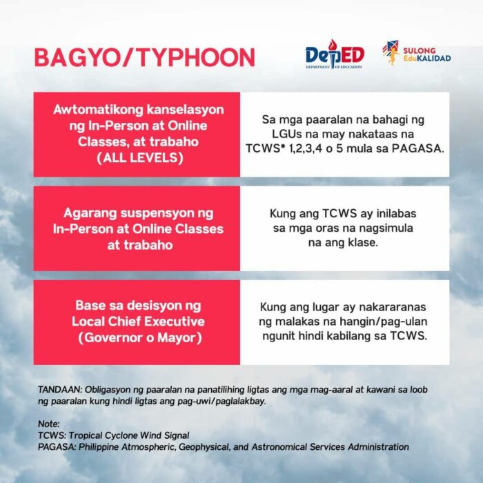
Typhoon
In-person and online classes at all levels are automatically canceled in schools situated in Local Government Units (LGUs) issued with Tropical Cyclone Wind Signals (TCWS) 1, 2, 3,4, or 5 by the Philippine Atmospheric, Geophysical, and Astronomical Services Administration (PAGASA).
If the TCWS is issued at a time when classes have already begun, the school shall immediately suspend the classes and work and send everyone home if it is safe to do so. However, schools must keep students and personnel safe in school if traveling has become unsafe.
Local Chief Executives shall decide on the cancellation or suspension of classes in cases where there are strong winds in specific or all areas of the LGU but is not due to a typhoon.
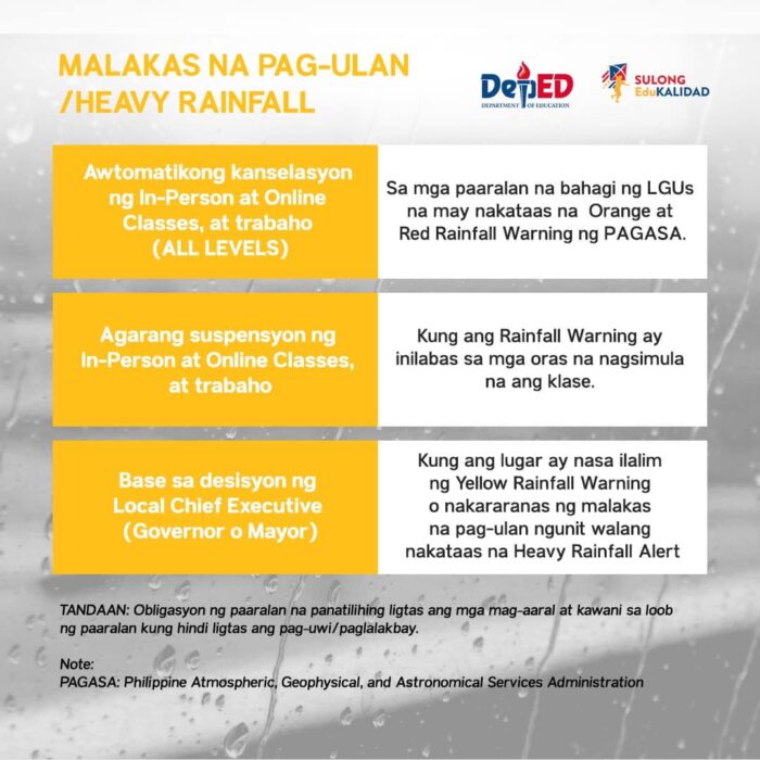
Heavy Rainfall
In-person and online classes at all levels are automatically canceled in schools situated in LGUs issued with Yellow, Orange, and Red Rainfall Warnings by the PAGASA.
If the Warning is issued when classes have already begun, the school shall immediately suspend the classes and work and send everyone home if it is safe to do so. However, schools are obligated to keep the students and personnel safely in school if traveling has become unsafe.
Local Chief Executives shall decide on the cancellation or suspension of classes in cases where there are torrential rains in specific or all areas of the LGU but is not issued a Heavy Rainfall Alert by PAGASA.
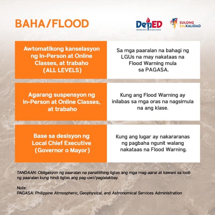
Flood
In-person and online classes in all levels are automatically canceled in schools situated in LGUs issued with a Flood Warning by the PAGASA.
If the Flood Warning is issued at a time when classes have already begun, the school shall immediately suspend the classes and work and send everyone home if it is safe to do so. However, schools are obligated to keep the students and personnel safely in school if traveling has become unsafe.
Local Chief Executives shall decide on the cancellation or suspension of classes in cases where there is flooding in specific or all areas of the LGU but is not issued a Flood Warning by PAGASA.

Responsibility of Parents or Guardians
The DepEd still maintains that parents or guardians are responsible for determining whether their children should attend classes considering their physical and/or mental health during disasters and calamities. This applies even if no order for cancellation or suspension of classes has been issued.
However, it is also the responsibility of the parents or guardians to ensure that their child can catch up with the needed competencies that the learners should master.
For more information, read DO 37, s. 2022: https://bit.ly/DO37S2022
*Suspension of classes for the tertiary level (colleges and universities) will be at the discretion of school management.

Flight Cancellations in the Philippines
(Please refresh this post for flight updates from Philippine Airlines, Cebu Pacific, and AirAsia Philippines.)
Philippine Weather Updates: Some Classes on Wednesday, August 30, 2023, have been canceled due to Typhoon Goring (Saola) and the enhanced southwest monsoon.
Keep refreshing this page for more #WalangPasok updates.
Bookmark us, like us on Facebook, follow us on Twitter, and subscribe to our feeds to get the latest updates on class suspensions.
Searching for the best hotels and affordable flights? Check out our complete list of affordable hotels and resorts via Agoda, or you may also see available Airbnb properties in the city.
May Pasok or Walang Pasok? Want more Updates? Please follow #TeamOutofTown, on Facebook, Twitter, Instagram, and Pinterest for more walang pasok updates.
Also Read: